|
Geographic Geometry
|
|
A NEW LOOK AT AN OLD DESIGN
Exploring Geographic and Geometric Relationships
Along a Line of Ancient Sites Around the World BY JIM ALISON |
|
PART I - GEOGRAPHIC RELATIONSHIPS
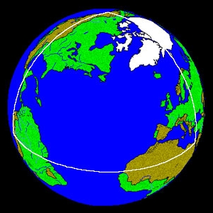
The Great Pyramid is aligned with Machu Picchu, the Nazca lines and Easter Island along a straight line around the center of the Earth, within a margin of error of less than one tenth of one degree of latitude. Other sites of ancient construction that are also within one tenth of one degree of this line include: Perseopolis, the capital city of ancient Persia; Mohenjo Daro, the ancient capital city of the Indus Valley; and the lost city of Petra. The Ancient Sumarian city of Ur and the temples at Angkor Wat are within one degree of latitude of this line. The alignment of these sites is easily observable on a globe of the Earth with a horizon ring. If you line up any two of these sites on the horizon ring, all of the sites will be right on the horizon ring. 3-D world atlas software programs can also draw this line around the Earth. Start on the Equator, at the mouth of the Amazon River, at 49� 17' West Longitude; go to 30� 18' North Latitude, 40� 43' East Longitude, in the Middle East, which is the maximum latitude the line touches; then go to the Equator at 130� 43' East Longitude, near the Northwest tip of New Guinea; then to 30� 18' South Latitude, 139� 17' West Longitude, in the South Pacific; and then back to 49� 17' West Longitude, at the Equator.
| ||||||||
The circumference of this line around the center of the Earth is 24,892 miles. Along this line, the great circle distance from the Great Pyramid to Machupicchu is
7,487 miles, 30.0% of the circumference. Machupicchu is 2,564 miles from Easter Island, 10.3%. Easter Island is 10,096 miles from Angkor Wat, 40.6%. Angkor
Wat is 2,490 miles from Mohenjo Daro, 10.0%. Mohenjo Daro is 2255 miles from from the Great Pyramid, 9.1%. In addition to calculating the distances between
these sites as a percentage of the circumference of the Earth, the distances may also be calculated in degrees of the 360� circumference, by multiplying the percentage
by 3.6. For example, the Great Pyramid is 108� away from Machupicchu.
Angkor Wat and Angkor Thom were constructed at a time when 72 temples were built across the Angkor Plain. The Angkor temple at Prassat Preah Vihear, 90 miles Northeast of Angkor Wat, is within one tenth of one degree of the line. Like Machupicchu, the temple at Prassat Preah Vihear was built on the edge of a mountaintop. The first temples built around Angkor are near the city of Rolous, Southeast of Angkor Wat. The temples near Rolous are also thought to have been built on foundations constructed at a much earlier time. Halfway between Angkor Wat and the Great Pyramid is the Indus Valley, the city of Mohenjo Daro, and the unexcavated city of Ganweriwala, which is East of Mohenjo Daro, and thought to be just as large. Both of these sites are on the line between Angkor and the Great Pyramid. The Indus Valley is also antipodal to Easter Island. It is an interesting coincidence concerning these two sites, opposite each other on Earth, that of the few ancient written languages of the world that remain undeciphered, two are Indus Valley Script and Rongorongo, the written language of ancient Easter Island. The world's first known written languages, Egyptian Hieroglyphics and Sumerian Cuneiform, were also developed along this line of ancient sites. The Jewish, Christian, Muslim, Hindu, Brahman and Buddhist religions, as well as ancient Egyptian and Peruvian religions, were also developed along this line. Anatom Island is the southernmost Island in the new Republic of Vanuatu, formerly known as the New Hebrides. Anatom Island is exactly halfway between Easter Island and Angkor Wat 5,048 miles each way, or 20.3% of the circumference of the Earth. Stone ruins on Anatom Island once housed the largest missionary church in the southern hemisphere. The line crosses over the source and the mouth of the Amazon, the mouth of the Nile, the mouth of the Tigris-Euphrates, the Indus River and the Bay of Bengal near the mouth of the Ganges. The line also crosses over a number of areas of the world that are largely unexplored or unexcavated, including the Sahara Desert, the Brazilian Rainforest, the highlands of New Guinea, and underwater areas of the North Atlantic Ocean, the South Pacific Ocean and the South China Sea. For example, the midway point between the Great Pyramid and Machupicchu is in the North Atlantic Ocean, less than one degree south of the Cape Verde Islands. This is also the midway point between Easter Island and the Indus Valley. Although the Cape Verde Islands were found to be uninhabited when they were rediscovered in 1460 A.D., maps and geographical descriptions for the past 2000 years have shown this location to be the home of ancient island civilizations, including maps showing this location to be the site of Atlantis. In Plato's account of Atlantis, there was a mountainous region north of the city. Are the higher elevations of those mountains now the Cape Verde Islands? | ||||||||
PART 2 - GOLDEN SECTION SITES - ANGKOR, THE GREAT PYRAMID & NAZCA
Angkor Wat is 4,745 miles from the Great Pyramid and the Great Pyramid is 7,677 miles from Nazca. This is a precise expression of ?, the Golden Section: 4,745 x 1.618 = 7,677
| ||||||||||||||||||||

These Golden Section relationships may also be diagramed on a straight line: The line of ancient sites is a line, from the perspective of the illustration in Part One, and it is a circle, from the perspective of the illustration in Part Six. The line and the circle are found in the greek letter phi and the number 10. Zero and one are also the first two numbers and the only two numbers in the binary code. The phi relationships between these sites are reflected repeatedly in the first 500 Fibonacci numbers. The first three prime numbers, 2, 3 and 5, approximate the intervals along the circumference of 20%, 30% and 50%, between these three sites. This same percentage of the circumference relationship, accurate to three digits, is found in Fibonacci numbers 137-139:
The next prime Fibonacci number after #137 is #359.
|
PART 3 - LINES THROUGH THE EARTH
The circle is oriented so that the two points where the circle crosses the equator are on the horizontal axis, and the two points where the circle reaches its greatest latitudes are on the vertical axis.
| ||
 Straight lines may be drawn through the Earth, connecting Easter Island to Machupicchu, the
Great Pyramid, Angkor Wat, and the Indus Valley (antipodal to Easter Island).
Straight lines may be drawn through the Earth, connecting Easter Island to Machupicchu, the
Great Pyramid, Angkor Wat, and the Indus Valley (antipodal to Easter Island).
The straight line distance, through the Earth, from Angkor Wat to Easter Island (7,574 miles), plus the straight line distance from Easter Island to Macchupicchu (2,522 miles), equals the great circle distance from Angkor Wat to Easter Island (10,096 miles). The straight line distance from the Great Pyramid to Easter Island (7,566 miles) is three times the straight line distance from Easter Island to Machupicchu (2,522 miles). The straight line distance from Easter Island to its antipodal point in the Indus Valley (7,924 miles), which is also the diameter of the Earth, is 3.1416 times the straight line distance from Easter Island to Machupicchu (2,522 miles), a precise expression of phi. Since the circumference of the Earth is also 3.1416 times the diameter of the Earth, the straight line distance from Easter Island to Machupicchu times pi� equals the circumference of the Earth. The angle formed by the lines from Easter Island to Machupicchu, and to the Indus Valley, is 72�. The angle formed by the lines from Easter Island to Machupicchu, and to the Great Pyramid, is 54�. | ||
 Lines connecting Easter Island, the Great Pyramid, and the Angkor temples near Rolous, form an
isosceles triangle with base angles of 72.9�. The base of this triangle (AG) is 4462 miles long. The
height of this triangle (HE) is 7220 miles long. The length of the base of the triangle times phi equals the height of the triangle:
4,462 miles x 1.618 = 7,220 miles
Lines connecting Easter Island, the Great Pyramid, and the Angkor temples near Rolous, form an
isosceles triangle with base angles of 72.9�. The base of this triangle (AG) is 4462 miles long. The
height of this triangle (HE) is 7220 miles long. The length of the base of the triangle times phi equals the height of the triangle:
4,462 miles x 1.618 = 7,220 miles
755.6 feet � 2 = 377.8 feet
The ratio of the base to the slant height of the Great Pyramid is exactly two times the ratio of the base to the height of the triangle formed by through the earth straight lines connecting the Great Pyramid, Angkor and Easter Island. | ||
 Lines connecting Easter Island with it's antipodal point in the Indus Valley, Nazca with it's
antipodal point at Angkor, Easter Island with Nazca and Angkor with the Indus Valley, form
two isosceles triangles with base angles of 72.9�. With the same angular dimensions as the
triangle formed by Easter Island, Angkor and the Great Pyramid, the length of the bases of these
triangles times phi also equals the height of these triangles:
Lines connecting Easter Island with it's antipodal point in the Indus Valley, Nazca with it's
antipodal point at Angkor, Easter Island with Nazca and Angkor with the Indus Valley, form
two isosceles triangles with base angles of 72.9�. With the same angular dimensions as the
triangle formed by Easter Island, Angkor and the Great Pyramid, the length of the bases of these
triangles times phi also equals the height of these triangles:
2,337 miles x 1.618 = 3,782 miles The ratio of the base to the slant height of the Great Pyramid is also exactly two times the ratio of the base to the height of the triangles formed by through the earth straight lines connecting Easter Island, Nazca and the center of the Earth, and Angkor, the Indus Valley and the center of the Earth. | ||
Because the distance between the Great Pyramid and Angkor is very nearly 20% of the circumference, they are very nearly 72� apart, along the circle. Because the
distance from the Great Pyramid to Easter Island is very nearly 40% of the circumference, and the distance from Angkor to Easter Island is very nearly 40% of the
circumference, the Great Pyramid and Angkor are both very nearly 144� away from Easter Island, along the circle.
The number 72, and to a lesser extent the numbers 54, 108, and 144, have been associated with the designs of these sites, particularly at the Great Pyramid and Angkor. The ratio of the height and the perimeter of the Great Pyramid, to the size of the Earth, is a multiple of 72. The number of temples built around Angkor is 72, and the number 54 is reflected in the numbers of statuary in the temples at Angkor. The use of these numbers is also prevalent in ancient writings and folklore surrounding these sites. The number 54 is itself a factor of 72, in that 72 plus � of 72, or 36, equals 108, which divided by two equals 54. The number 72 is also associated with the astronomical phenomenon known as precession, because 72 years is the length of time it takes for the constellations to move one degree due to precession. This has been offered as an explanation for the use of these numbers, suggesting that the builders of these sites were aware of the precession of the equinoxes. In the 2nd century B.C., the Greek mathematician, Archimedes, wrote an article entitled The Sand Reckoner, in which he cited earlier Greek mathematicians (like Archimedes, they had studied in Alexandria and Heliopolis) who had calculated that the Sun occupied 1/720 of the circle of the constellations. This may be an additional, or alternative, explanation for the prevalence of the number 72, and its multiples and factors, found in these sites. In any event, the existence of these numbers in the geometric relationships between these sites is complementary to the use of these numbers in their internal designs. |
 The line of ancient sites may be viewed as a circle because all of the sites are on a
straight line around the center of the Earth. The intervals between the sites are based on
their great circle distances from each other.
The line of ancient sites may be viewed as a circle because all of the sites are on a
straight line around the center of the Earth. The intervals between the sites are based on
their great circle distances from each other.
 The length of the base of each face of the Great Pyramid is 755.6 feet. The slant height of each
face is 611 feet. One half of the length of the base times phi equals the slant height of the Great Pyramid:
The length of the base of each face of the Great Pyramid is 755.6 feet. The slant height of each
face is 611 feet. One half of the length of the base times phi equals the slant height of the Great Pyramid:
PART 4 - THE GREAT PYRAMID AND THE 30th PARALLEL
|
 This diagram illustrates that the relationship of the 30th parallel to the circumference of
the Earth is the geometric relationship known as the Vesica Pisces. In relation to the
lower circumference, DE is at 30� N latitude. In relation to the upper circumference,
DE is at 30� S latitude. The ratio between the straight line distance of the 30th parallel
and the radius of the Earth is 1.732 to one. 1.732 is the square root of three.
This diagram illustrates that the relationship of the 30th parallel to the circumference of
the Earth is the geometric relationship known as the Vesica Pisces. In relation to the
lower circumference, DE is at 30� N latitude. In relation to the upper circumference,
DE is at 30� S latitude. The ratio between the straight line distance of the 30th parallel
and the radius of the Earth is 1.732 to one. 1.732 is the square root of three.
|
 Paul Michell and Charles Henry have noted the relationship between the Great Pyramid and the
Vesica Pisces. The small circles in this diagram are one inch in diameter, and the large circles are
three inches in diameter, forming a small Vesica Pisces circumscribed by a larger one. The
triangle in this diagram has the same angular dimensions as the Great Pyramid.
Paul Michell and Charles Henry have noted the relationship between the Great Pyramid and the
Vesica Pisces. The small circles in this diagram are one inch in diameter, and the large circles are
three inches in diameter, forming a small Vesica Pisces circumscribed by a larger one. The
triangle in this diagram has the same angular dimensions as the Great Pyramid.
|
 The circle in this diagram also represents the circumference of the Earth with the poles on the vertical
axis. The radius of the circle is 1.00 inch. The exterior and interior equilateral triangles touch the circle
only at the 30th parallels and the poles. The height of each equilateral triangle is 87% of the length of
each of it�s sides:
The circle in this diagram also represents the circumference of the Earth with the poles on the vertical
axis. The radius of the circle is 1.00 inch. The exterior and interior equilateral triangles touch the circle
only at the 30th parallels and the poles. The height of each equilateral triangle is 87% of the length of
each of it�s sides:
3.00 � 3.46 = .87 1.50 � 1.73 = .87 1.00 � 1.15 = .87 The length of each of the sides of the interior triangles, including the straight line distance through the earth at the 30th parallel, is also 87% of the diameter of the Earth: 1.73 � 2.00 = .87 The radius of the Earth is also 87% of the distance from the center of the Earth to the point of the exterior triangles� intersections (AP, AQ, AR, etc.): 1.00 � 1.15 = .87 The Greek foot is thought to have been developed before the size and shape of the Earth was known and independently from the foot, which is also thought to have been developed before the size and shape of the Earth was known. The foot is 87% of the length of the Greek foot. The mile, which is thought to have been developed before the size and shape of the Earth was known, is 87% of the length of the nautical mile, which was developed specifically in relation to the size of the Earth. The nautical mile equals one minute of latitude, so 60 nautical miles equals one degree of latitude and 5,400 nautical miles equals the 90 degrees of latitude between the Equator and the poles. The distance from the Equator to the poles is 6,215 miles: 5,400 � 6,215 = .87 One minute of latitude equals one nautical mile at any longitude. At the equator, one minute of longitude also equals one nautical mile, but at higher latitudes, the distances between each minute of longitude become shorter. Because the straight line distance through the Earth at the 30th parallel is 87% of the diameter of the Earth, the circumference around the Earth at the 30th parallel is 87% of the circumference of the Earth at the Equator, and each minute of longitude at the 30th parallel is 87% of the distance of each minute of longitude at the Equator. As a result, just as one nautical mile equals one minute of longitude at the Equator, one standard mile equals one minute of longitude at the 30th parallel. The currently accepted value for the Equatorial diameter of the Earth is 7,926 miles, with an Equatorial radius of 3,963 miles. The ratio of the radius of the Earth to the straight line distance through the Earth at the 30th parallel is 1:1.732. 3,963 miles x 1.732 = 6,864 miles (the straight line distance through the Earth at the 30th parallel). 6,864 miles x pi = 21,564 miles (the circumference of the Earth at the 30th parallel). 21,564 miles � 360 degrees = 59.9 miles (one degree of longitude at the 30th parallel). 59.9 miles � 60 minutes = .998 miles (one minute of longitude at the 30th parallel). As an alternative proof, the currently accepted value for the Equatorial circumference of the Earth is 24,902 miles, and the circumference of the 30th parallel is 87% of the circumference of the Earth. 24,902 miles x .87 = 21,664 miles (the circumference of the Earth at the 30th parallel). 21,664 miles � 360 degrees = 60.1 miles (one degree of longitude at the 30th parallel). 60.1 miles � 60 = 1.00 miles (one minute of longitude at the 30th parallel). Conclusion: One minute of longitude equals one mile at (or, like the Great Pyramid, just below) the 30th parallel. |
 This circle has a different orientation than the previous diagrams and is two inches in diameter. The
horizontal axis is the Equator, FC is the 30th parallel, D is 60� North latitude and E is the North Pole. The
30th parallel is exactly one-third of the great circle distance from the Equator to the North Pole, and it is
located at exactly one-half of the height of the Northern Hemisphere. Like the Great Pyramid, the
maximum latitude of the line of ancient sites is very close to the 30th parallel.
This circle has a different orientation than the previous diagrams and is two inches in diameter. The
horizontal axis is the Equator, FC is the 30th parallel, D is 60� North latitude and E is the North Pole. The
30th parallel is exactly one-third of the great circle distance from the Equator to the North Pole, and it is
located at exactly one-half of the height of the Northern Hemisphere. Like the Great Pyramid, the
maximum latitude of the line of ancient sites is very close to the 30th parallel.
PART 5 - ALIGNMENTS OF THE NAZCA LINES & FIGURES
Nazca is marked by the yellow cross on the illustration [below]. The vertical line in the center of the picture is 75� West Longitude. The horizontal line is 15� South Latitude. The white dot touching the north side of the line on the upper right side of the illustration is Machupicchu. |
|
This illustration of the Nazca lines has also been rotated so that the north-south axis is vertical,
and shows the primary orientation of the lines is from Southwest to Northeast, along the line of ancient sites.
|
 The glyphs and lines at Nazca are oriented along the line of ancient sites. This image of the glyphs at Nazca, with a
compass bearing, is available on the internet, but it is usually oriented away from the cardinal points so that the
figures are roughly horizontal and vertical. Rotating this image so that the north-south axis is vertical, aligns the
figures and geometric drawings to the line of ancient sites as it crosses Nazca.
The glyphs and lines at Nazca are oriented along the line of ancient sites. This image of the glyphs at Nazca, with a
compass bearing, is available on the internet, but it is usually oriented away from the cardinal points so that the
figures are roughly horizontal and vertical. Rotating this image so that the north-south axis is vertical, aligns the
figures and geometric drawings to the line of ancient sites as it crosses Nazca.
PART 6 - THE AXIS POINTS
Just as every point along the equator is 6,215 miles from both the North and South Poles, every point along the line of ancient sites is 6,215 miles from two axis points on Earth. The axis point in the Northern Hemisphere is near the Southeastern coast of Alaska, at 59� 42' N 139� 17' W, 25 miles Northeast of Yakutat, Alaska The North and South Poles have not always been in their present locations. Several theories have been offered to explain observed and suspected movements of the poles in relation to the surface of the Earth. Plate tectonics, the prevailing theory, suggests gradual movements of the surface of the Earth. This theory has been called into question by recent measurements of relative movements of the earth's surface, and by accumulating seismological data. Alternative theories include: Axial shifts; polar wander; and a catastrophic form of polar wander known as Earth crust displacement.
This is about 250 miles Northeast of the axis point for the line of ancient sites at 59� 42' N 139� 17' W. It is interesting to note that some of the heaviest remaining glaciation in all of North America is on the Southeastern coast of Alaska, surrounding Yakutat. If 59� 42' N 139� 17' W was the location of the North Pole, then the line of ancient sites would have been the equator at that time. The concentric circles in the diagram represent lines of latitude from 59� 42' N 139� 17' W. The circle closest to the center of the diagram is 75�N, followed by 60�N, 45�N, 30�N and 15�N. The line of ancient sites is just beyond the horizon. Since many of the sites along the line are precisely oriented to the present North and South Poles, it is not suggested that they were constructed when the poles were in a prior location. However, if this line had previously been the equator, the placement of these sites on this line would be a remarkable coincidence. In a book entitled Atlantis Blueprint, Rand Flem-Ath and Colin Wilson have listed some of these sites, and a number of other sites, in relation to their calculation of the North Pole in the Yukon, including sites that would have been on the equator during this prior polar alignment. A line around the center of the earth, with the Yukon Pole as it�s axis point, approaches and crosses over the line of ancient sites at antipodal points in Peru and Cambodia. Along the line of ancient sites, the sites in these two areas are close to being equally distant from the Yukon Pole and from the Yakutat axis point. None of the theories offered to explain the motions of the surface of the Earth, relative to the poles, can pinpoint exact prior polar positions. The round number coordinates that are used by Hapgood and the Flem-Aths for the Yukon Pole indicate that they are approximations. If the line of ancient sites was originally selected because of its equatorial relationship with a prior polar alignment, the most accurate way to determine the location of the prior alignment is to simply calculate it from the location of the line of ancient sites. |
 Charles Hapgood advocated the Earth crust displacement theory in a book entitled The Path of the Poles. Hapgood
supported this theory with geomagnetic and carbon dated evidence. In a book entitled When the Sky Fell, Rose
and Rand Flem-Ath also advocate the Earth crust displacement theory, with additional geological and archeological
evidence. Both of these works conclude that the North Pole was located in the Yukon, at 63� N 135� W,
approximately 80,000 to100,000 years ago.
Charles Hapgood advocated the Earth crust displacement theory in a book entitled The Path of the Poles. Hapgood
supported this theory with geomagnetic and carbon dated evidence. In a book entitled When the Sky Fell, Rose
and Rand Flem-Ath also advocate the Earth crust displacement theory, with additional geological and archeological
evidence. Both of these works conclude that the North Pole was located in the Yukon, at 63� N 135� W,
approximately 80,000 to100,000 years ago.
PART 7 - THE GREAT PYRAMID, PERU & PYTHAGORAS
The Great Pyramid precisely expresses the 2pi relationship between the circumference and the radius of the Earth. The height of the Great Pyramid is 481.4 feet. The perimeter of the Great Pyramid (the length of all four sides at the base of the pyramid) is 3,023 feet. The height of the Great Pyramid times 2pi (6.28) is 3,023 feet.
Inspired by Charles Hapgood's Earth crust displacement theory, Jim Bowles, a retired NASA engineer, wrote The Gods, Gemini, and the Great Pyramid. In his book, Bowles provides a scientific explanation for the causes of Earth crust displacements. He also discusses many similarities between the lines and figures at Nazca, the Great Pyramid and ancient Egyptian hieroglyphic texts. Bowles observes that the Great Pyramid and the Nazca lines and figures would have been on the equator if the North Pole had been in southeastern Alaska, and in a lengthy proof using coordinate derivations and spherical trigonometry he demonstrates the 2pi relationship between the three sites. Of course, this 2pi relationship exists between the Great Pyramid, Nazca and the axis point for the line of ancient sites, regardless of whether or not the axis point was once the North Pole.
3.1416 x 2 = 6.2832 4,887.72 miles x 6.2832 = 30,710.4 miles 7,677.6 miles x 4 = 30,710.4 miles
The distances between the Great Pyramid, Machupicchu, and the axis point of the line of ancient sites, express this same 3-4-5 relationship. The distance from the Great Pyramid to Machupicchu (7,487 miles) is exactly 30.0% of the circumference of the Earth. The distance from the Great Pyramid and from Machupicchu to the axis point for the line of ancient sites is exactly 25% of the circumference of the Earth. Dividing this isosceles triangle by it's height forms two 15%-20%-25% right triangles. |
 The relationship of the distances between the Great Pyramid, Nazca, and the axis point of the line of ancient sites, precisely expresses this same 2pi relationship.
 This relationship may also be demonstrated by diagramming the great circle distances between the three sites on a
flat surface. Along the line of ancient sites, the distance from the Great Pyramid to the Nazca lines is 7,677.6
miles. The distance from the line of ancient sites to the axis point in southeastern Alaska is 6,215 miles. This
triangle, with a base of 7,677.6 miles and sides of 6,215 miles, forms an isosceles triangle with base angles of 51�
51' and a height of 4,887.72 miles. The height of the triangle is calculated using Pythagoras' theory (a� + b� = c�).
The height of the triangle times 2pi equals the base of the triangle times four.
This relationship may also be demonstrated by diagramming the great circle distances between the three sites on a
flat surface. Along the line of ancient sites, the distance from the Great Pyramid to the Nazca lines is 7,677.6
miles. The distance from the line of ancient sites to the axis point in southeastern Alaska is 6,215 miles. This
triangle, with a base of 7,677.6 miles and sides of 6,215 miles, forms an isosceles triangle with base angles of 51�
51' and a height of 4,887.72 miles. The height of the triangle is calculated using Pythagoras' theory (a� + b� = c�).
The height of the triangle times 2pi equals the base of the triangle times four.
 Another special triangular relationship, found in the dimensions of the King's Chamber in the Great Pyramid, is the 3-4-5 right triangle that elegantly expresses
Pythagoras' theory (3� + 4� = 5�). In the King's Chamber, the diagonal length of the east wall is 309", the length of the chamber is 412", and the long central diagonal
is 515". The stone over the entrance to the King's Chamber is the only stone in the walls that is two courses high. This stone also expresses a 3-4-5 right triangle
relationship by its measurements of 124"L x 93"H x 155" diagonal.
Another special triangular relationship, found in the dimensions of the King's Chamber in the Great Pyramid, is the 3-4-5 right triangle that elegantly expresses
Pythagoras' theory (3� + 4� = 5�). In the King's Chamber, the diagonal length of the east wall is 309", the length of the chamber is 412", and the long central diagonal
is 515". The stone over the entrance to the King's Chamber is the only stone in the walls that is two courses high. This stone also expresses a 3-4-5 right triangle
relationship by its measurements of 124"L x 93"H x 155" diagonal.
PART 8 - EASTER ISLAND SYNCHRONICITY
1.95 x 1.618 = 3.16. The Great Pyramid is 10,055 miles from the Southwestern volcanic peak on Easter Island. A triangle formed by the great circle distances between Easter Island, the Great Pyramd, and the axis point for the line of ancient sites in S. E. Alaska, has the same angular dimensions as the triangle formed by the volcanic peaks on Easter Island, and also precisely expresses phi: 6, 215 x 1.618 = 10,055
|
 The large triangles in five pointed stars have these same angular dimensions, and express the same phi
relationship. All of the angles in five pointed stars, 36�, 72� and 108�, are numbers that have been associated
with the precession of the equinoxes, as well as the internal designs of the Great Pyramid and other ancient sites around the world.
The large triangles in five pointed stars have these same angular dimensions, and express the same phi
relationship. All of the angles in five pointed stars, 36�, 72� and 108�, are numbers that have been associated
with the precession of the equinoxes, as well as the internal designs of the Great Pyramid and other ancient sites around the world.
There are 72 major monuments at Angkor, 108 stone figures surround Angkor Thom, and the highest terraces of Angkor Thom house 72 Buddhas in latticework stupas.
3,841 x 1.618 = 6,215. These relationships are also clearly demonstrated by the metric system, which is based on a distance of 10,000 kilometers from the North Pole to the Equator. The distance from Easter Island to the Great Pyramid is 16,180 kilometers and the distance from Ur to Angkor is 6,180 kilometers: 6,180 x 1.618 = 10,000. 10,000 x 1.618 = 16,180. |
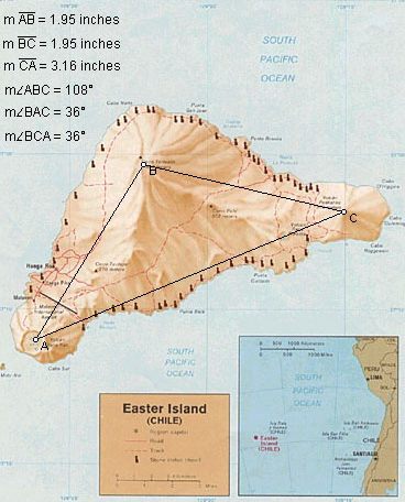 The three volcanic peaks on Easter Island form an isosceles triangle with base angles of 36�. The
relationship between the length of the base of this triangle and the lengths of the sides precisely
expresses phi:
The three volcanic peaks on Easter Island form an isosceles triangle with base angles of 36�. The
relationship between the length of the base of this triangle and the lengths of the sides precisely
expresses phi:
 The great circle distances between Angkor Thom, the ziggurat at Ur, and the axis point of the
line of ancient sites, forms an isosceles triangle with base angles of 72�. The small triangles in
five pointed stars have these same angular dimensions, also precisely expressing phi:
The great circle distances between Angkor Thom, the ziggurat at Ur, and the axis point of the
line of ancient sites, forms an isosceles triangle with base angles of 72�. The small triangles in
five pointed stars have these same angular dimensions, also precisely expressing phi:
PART 9 - WHERE IN THE RAINFOREST
After the discovery of America by Europeans, there were early reports an abandoned city of megalithic stone construction in the Amazon rainforest. The legendary golden city of El Dorado was also believed to be hidden under the rainforest. Explorers such as Percy Fawcett and Sir Walter Raleigh have searched for these sites, but their location(s) remain unknown.
As the line of ancient sites goes around the Earth, the azimuth, or compass bearing, of the line changes. It is interesting to note that at 4� 10' S, 56� 19' W, the azimuth of the line of ancient sites is precisely 60� (the angle between the line of ancient sites going in the direction of the Great Pyramid, and a verticle line of longitude going North). | ||
|
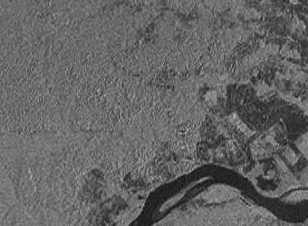
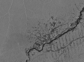
The Amazon Basin has been mapped by satellite photography, but most areas are hidden under the rainforest.
These are satellite images of Itaituba and 4� 10' S, 56� 19' W. The image on the right is a 4x magnification. The dark areas on the images are areas where the forest
has been cleared around Itaituba.
If the special triangular relationships between the axis point of the line of ancient sites, the Great Pyramid, Nazca and Machupicchu are not coincidences, a good place to look for another marker of geometric significance would be six miles northeast of the village of Paraiso, at 4� 10' S, 56� 19' W. |
 Along the line of ancient sites, the great circle distance from the Great Pyramid to 4� 10' South Latitude, 56� 19' West
Longitude, is 6,215 miles (exactly 25% of the circumference of the Earth). The distance from these sites to the axis point
in Southeast Alaska is also 6,215 miles, forming a perfect equilateral triangle.
Along the line of ancient sites, the great circle distance from the Great Pyramid to 4� 10' South Latitude, 56� 19' West
Longitude, is 6,215 miles (exactly 25% of the circumference of the Earth). The distance from these sites to the axis point
in Southeast Alaska is also 6,215 miles, forming a perfect equilateral triangle.
 During construction of the Transamazon highway, significant gold deposits were discovered near
Itaituba. There are numerous caverns with drawings over 8,300 years old in this area, including
caverns along the line of ancient sites near Paraiso and Itaituba.
During construction of the Transamazon highway, significant gold deposits were discovered near
Itaituba. There are numerous caverns with drawings over 8,300 years old in this area, including
caverns along the line of ancient sites near Paraiso and Itaituba.
PART 10 - LIGHT AND SHADOW - THE FACE IN THE ANDES
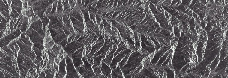
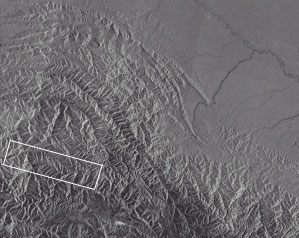
On November 7, 1995, this satellite image of the Peruvian Andes was generated by synthetic aperture radar. This image may also be viewed at NASA's Tropical
Rainforest Information Center, on tile X23 - mosaic 123 - image 151330724195311. In the middle of the image below, about three inches from the left edge, is
Machupicchu, Peru, although Machupicchu does not have structures large enough to be clearly visible. Near the line of ancient sites, about twenty miles east of
Machupicchu (two inches from the top of the image below and an inch from the right edge) is the image pictured above.
|
PART 11 - SINE LANGUAGE
As the Earth rotates on it�s axis, the Equator remains aligned, but the line of ancient sites describes a sine wave as a result of it�s tilt relative to the Equator. The line of the ecliptic may be observed describing a similar wave by spinning a globe that has a line of the ecliptic. The wave may also be visualized by drawing the line of ancient sites on a flat projection of the Earth.
Harmonics, electricity, and many other aspects of nature are based on sine waves. Because this particular wave repeats with each full rotation of the earth, the frequency of the wave is equal to the circumference of the Earth. The amplitude of this wave, measured from the middle of the wave (the equator), is 30� of latitude. Recall that the 30th parallels are � of the height of each hemisphere, or � of the radius of the Earth. Since the height of the wave is equal to � of the Earth�s radius, the ratio between the frequency of the wave and it�s amplitude is 4pi. Measuring the amplitude from the top of the wavelength to the bottom (from 30� N to 30� S), the amplitude is equal to the radius of the Earth, and the ratio between the frequency and the amplitude of the wave is 2pi. |
PART 12 - CONCLUSION
Many similarities between these sites have been well documented, including the use of perfectly cut and precisely placed monolithic stones, exact orientations to the cardinal points and astronomical orientations. The prevailing view of world history dismisses these similarities as coincidental developments of separate stone age cultures. Unless it is also a coincidence that these sites are located at mathematically and geometrically significant points on a single line around the center of the Earth, it may be time to reconsider the idea that Europeans of the present era were the first to know the size and shape of the Earth.
Another good place to look might be halfway between the Great Pyramid and Easter Island, at 4� 19' North Latitude, 41� 30' West Longitude, also under the North Atlantic Ocean: G = Great Pyramid A = Angkor Wat V = Anatom Island E = Easter Island X = Atlantis? The distance from the Great Pyramid to Easter Island is approximately 40% of the circumference of the Earth. The X in the diagram is halfway between the two, 20% each way. Machupicchu is halfway between the X in the diagram and Easter Island, 10% each way. The Distance from the Great Pyramid to Angkor Wat is approximately 20% of the circumference, and the Indus Valley is halfway between the two, 10% each way. The Distance from Easter Island to Angkor Wat is approximately 40% of the circumference, and Anatom Island is halfway between them, 20% each way. These sites are located in multiples of 10% of the circumference of the Earth, and particularly at 20% intervals. Although there are no islands near the location of the X in the diagram, it is interesting to note that the famous Piri Reis map shows a large island in this location, and the geology of recent core samples, taken from the ocean floor in this area, is of continental rather than oceanic type rock. |
 If the locations of all of these sites is not a coincidence, and if there are sites yet to be discovered along the line, one good place to look might be halfway between the
Great Pyramid and Machupicchu, just south of the Cape Verde Islands.
If the locations of all of these sites is not a coincidence, and if there are sites yet to be discovered along the line, one good place to look might be halfway between the
Great Pyramid and Machupicchu, just south of the Cape Verde Islands.
PART 13 - COORDINATES, CALCULATION OF ALIGNMENT, OF ANCIENT SITES
|
PART 14 - OTHER GREAT CIRCLE ALIGNMENTS OF ANCIENT SITES
14.1 - A SECOND ALIGNMENT WITH EASTER ISLAND AND MOHENJO-DARO In Global Sacred Alignments, Terry Walsh diagrams several alignments of ancient sites on straight lines around the center of the earth, and mentions several others. He addresses the alignment of the Great Pyramid with Easter Island, Machupicchu and Perseopolis, and he diagrams an alignment of Easter Island with Tiahuanaco, Luxor, Varanasi and Bandiagara, the ancient capital city of the Dogons. This second alignment also crosses over Mohenjo Daro and Ganweriwali in the Indus Vallley.
Because Easter Island, Machupicchu, the Great Pyramid, the Indus Valley and Angkor are also aligned at 10% intervals around the earth, there is a high coincidence of paired sites along these two alignments. In addition to the convergence of the two alignments at Easter Island and Mohenjo-Daro, Machupicchu is paired with Tiahuanaco and the Great Pyramid is paired with Luxor. If the pairing of these sites along these two alignments is not a coincidence, two good places to look for other ancient sites would be in the Sahara Desert, near the border between Mali and Mauritania, at 21� N, 7� 40' W, 2,488 miles southwest of the Great Pyramid, and in the shallow water of the South China Sea, just off the coast of Vietnam, at 18� 43' N, 106� 27' E, 2,488 miles southeast of Mohenjo-Daro.
|
14.2 - A SECOND ALIGNMENT WITH THE GREAT PYRAMID
The Great Pyramid is aligned with the Temple Mount in Jerusalem; the Chinese city of Xian, site of the terracotta soldiers, the unexcavated tomb of Qin Shi Huang, the first Emperor of China, and numerous other pyramids and burial mounds; and the underwater ruins of Nan Madol that surround Pohnpei Island.
|
14.3 - A SECOND ALIGNMENT WITH MACHUPICCHU
Machupicchu, Ollantaytambo, Saqsaywaman and Cusco are aligned with Ingapirca; Tazumal, Mixco Viejo, Bonampak, Palenque, and La Venta; Mesa Verde and Chaco Canyon; Shanghai; and the partially submerged ancient capital city of Oc-Eo in the Mekong Delta.
|
14.4 - A SECOND ALIGNMENT WITH PERSEOPOLIS
Perseopolis is aligned with the ancient Sumarian/Babylonian/Assyrian center at Nippur; Baalbek and the ancient Phoenician city of Byblos; the ancient cities of Palaikastro and Knossos on the Island Of Crete; the Island of Malta; the North African sites of ancient Roman construction at Volubilis and Timgad; and the Incan and Pre-Incan fortress, temples and astronomical observatories at Ingapirca.
|
14.5 - A SECOND ALIGNMENT WITH LUXOR AND PALENQUE
In Global Sacred Alignments, Terry Walsh diagrams the alignment of Palenque, Bimini, Luxor and Mecca. The large Mayan city of Coba, site of the tallest Mayan pyramid, is also on this alignment.
|
14.6 - A CIRCLE WITH A CIRCUMFERENCE EQUAL TO THE 15TH PARALLELS
Northwest of the Acropolis, Delphi is close to the circle. Northwest of the Great Pyramid, the ancient capitals of Alexandria and Sais in Egypt are close to the circle. Several pyramids and other sites of ancient construction are south-south-east of the Great Pyramid and close to the circle. Likewise, a number of Mayan and Olmec sites between Palenque and Dzibilchitun on the Yucatan Peninsula are close to the circle. Similarly, in addition to Stonehenge, a number of megalithic sites in Southern England, Southern Ireland and Northern France are close to the circle.
|